Hot Springs Range Project

Deposit Type

Carlin-type Au
Low-sulfidation epithermal Au

Historic Production/Resource

NA

Geology

Mississippian-age calcareous sediments and andesites thrust over Permian phyllites. Host rocks coincide w/ crustal-scale subvertical faults.

Land Package

3,600 Ha

Exploration Target

Open-pit gold (oxide)
Underground Gold (oxide/sulfide)

Geochemistry

Soil sampling, 
surface rock chips

Mapping

1:10,000 scale geologic map

Previous Explorers

NA

Geophysics

CSAMT

Drilling

NA

Permitting

BLM Notice Level (Otis)
BLM Notice Level (Eden)

Key Statistics: Property Location, Size and Exploration Maturity

The project area is in northern Humboldt County, Nevada, and comprises 419 federal lode claims on BLM land, totaling 3,500 hectares, is located 50 km northeast of Winnemucca, NV and 20 km northwest of the Nevada Gold Mine’s Turquoise Ridge district (Getchell trend). To the Company’s knowledge, the area has never been explored for gold before (Figure 1).

Overview of the Opportunity

The Hot Springs Range exploration project targets a prospective Carlin-type gold system located at the northern portion of the NNE trending fork of Battle Mountain-Eureka Mineral Belt.  This well known, NW-NNW trending belt of world class deposits contains 50 Moz of gold.  At HSRP, this trend intersects another mineral belt, the NE-trending Getchell Trend, which, in and of itself, has a 40 Moz Au endowment.  (Figure 2). This location represents the northernmost exposure of Paleozoic rocks that the USGS identifies to be highly prospective to host Carlin-type mineralization (Figure 3) (Mihalsky, 1999; Mihalasky, 2001) and is in an area rated as highest for mineral potential (Figure 4). The fact that this intersection of world-class mineralized belts combined with highly prospective host rocks has never been explored is surprising and leads the Company to believe that HSRP has tremendous potential, especially considering that it occurs within 15 km of the Getchell-Turquoise Ridge mines which have produced >19 million ounces of gold (refer back to Figure 2).  Another indication for Carlin-type potential is the historical mercury mines immediately adjacent to the property, which share a marked similarity with mercury occurrences found 200 meters above Turquoise Ridge. (Johnson and Muntean, 2018).

Since the Company has acquired the property, it has further confirmed its prospectivity, and discovering what it believes to be two well-defined drill targets, the Otis and Eden targets (Figure 5 – Needs revised property outline to include 31 new claims at Eden). To accomplish this, the Company took 1312 soil samples at 125-meter centers at the Otis target, 79 soil samples at the Eden target and 157 rock samples.  The Company’s experienced technical team has also carefully mapped the geology at the property, looking, most importantly, for the key characteristics that would indicate a Carlin-type system.  As well as discovering a good host rock (see Mississippian unit in Figure 5), the Company discovered a remarkably similar structural architecture and history of reactivation aligning the HSRP with analogous architecture and structural reactivation at Turquoise Ridge (Chevillon et al., 2000; Johnson and Muntean, 2018; Muntean et al., 2009) (Figure 6 & 7 – 7 needs to be updated with revised comparative long section from NR). Anomalous geochemistry in predicted places has reinforced the results of the mapping: at the Otis target, prospective geochemistry (gold in soils up to 464 ppb, gold in rocks up to 2.8 g/t), occur exactly where one would expect, structurally and stratigraphically.

At the Eden target, the company discovered anomalous geochemistry in the pediment, seemingly associated with leakage up very recent faults with a very similar buried architecture as the Otis target.

Target Geology – Lithology, Structure, Alteration

Lithologic mapping focused on a previously mapped Mississippian age rock.  The company discovered that this formation consists of an extremely deformed and boudinaged limestone hosted within an iron rich andesitic flow, suggesting both good fracture permeability and good geochemical reactivity. This unit is intruded by a presumably Cretaceous age diorite sill.  It is all partially overlain by a much younger Tertiary basalt flow which is not altered and post-dates most of the significant lithology obscuring the main target (Figure 8).

Structural mapping confirms the presence of a low angle thrust fault, occurring beneath and bounding the Mississippian Limestone (the Home Ranch Fault) along which fluids appear to have flowed laterally as evidenced by alteration mapping and geochemistry (see below).  The mapping also confirms and reinforces the initial conceptual model of NW-SE and ENE-WSW oriented basin-forming faults, which are also partially obscured by the later Tertiary basalt.   These faults are the presumed feeder structures.

Alteration mapping, which accompanied rock sampling (see next section) reveals that the Mississippian limestone underwent decalcification followed by silica and sulfide replacement.  The bounding andesite flows have iron sulfide minerals, possibly an indication of its iron rich, sulfidizing potential.  The diorite sill, which is spatially and presumably temporally associated with the Home Ranch thrust fault, is also altered and contains some of the highest gold grades.  The alteration and mineralization all occur in the hanging wall of the Home Ranch Thrust within the Mississippian unit, confirming the prospectivity of both the thrust and the host rock. This alteration style is presumed to be to Late-Eocene type and age, as it not only mimics the alteration characteristics of the Late-Eocene age gold-associated mineralization of Turquoise Ridge, 20 km away but chalcedonic outflow silica was identified in the lowermost Tertiary sediments suggesting a hydrothermal system was active in the Late-Eocene. Further, recent rock sampling following up on 2020 mapping and results identified the highest Au contents to date proximal to the chalcedonic outflow silica but in the underlying Paleozoic rocks (see table, samples 133790, 133793, & 133778).

Otis Target model

Putting together the lithological, structural and alteration models with the prospective geochemistry, the Company has developed the following, well supported exploration hypothesis:  mineralization came up the high angle feeder structures until encountering the Home Ranch thrust fault and deformed prospective Mississippian host rock.  Mineralization would be abundant where the faults and prospective host rocks all intersect.  This intersection is buried by a thin layer of post-mineral, post structure basalt flows which must be drilled through to test this model. The conceptual intersection of high angle feeder faults with the low angle thrust fault at depth coincident with anomalous surface geochemistry was recently confirmed by geophysics (Figure 9). Geophysics images east-dipping feeder faults that are intersected at depth by antithetic, west-dipping faults. The intersection of the feeder faults occurs in immediate proximity to the low-angle Home Ranch thrust fault that places the receptive host rocks (ie. limestone and andesite) atop the feeder faults to create the ideal fluid plumbing for a Carlin-type system.   

Geochemical Results to Date

Anomalous geochemistry results associated with the aforementioned alteration consists of anomalous rock (up to 2.8 ppm Au) and soil (up to 465 ppb Au) samples which occur where the targeted Mississippian host rocks and along strike portions of the feeder faults daylight west of the post-mineral basalt flows which obscure these units to the east (Table 1, 2).

Sample ID Au (g/t) Ag (g/t) As ppm Hg ppm Sb ppm Se ppm Te ppm Tl ppm W ppm
133790 2.85 0.31 12.6 0.212 17.45 0.327 0.016 0.273 1.415
133793 2.52 0.471 219 1.02 131 0.377 0.027 1.25 5.42
133778 0.77 0.096 51.6 0.089 9.61 0.274 0.012 0.222 1.42
303524 0.706 0.028 457 0.453 19.05 0.272 0.007 0.562 4.56
303526 0.684 0.025 522 1.065 8.93 0.126 0.005 0.932 5.88
19PP03 0.405 0.014 764 4.46 31.5 0.757 0.007 1.125 3.26
303421 0.39 0.1 826 0.226 66 0.084 0.005 0.257 1.195
303419 0.355 0.063 1400 0.304 21.8 0.4 0.007 0.273 0.985
303533 0.25 1.01 263 2.06 19.55 0.767 0.024 0.389 5
303420 0.202 0.18 422 0.986 21.9 0.151 0.006 0.13 1.11
303438 0.138 0.003 571 0.013 8.19 0.22 0.005 0.684 2.75
19PP06 0.128 0.008 17 0.092 3.55 0.067 0.005 0.192 1.38

Table 1. Rock sample results from the Hot Springs Range Project – Otis Target area. Approximately 1 kg of material was collected for analysis and sent to the ALS lab in Elko, NV for preparation and then to Sparks, NV for analysis. All samples are assayed using 30g nominal weight fire assay with ICP finish (Au-ICP21) and multi-element four acid digest ICP-AES/ICP-MS method (ME-MS61). QA/QC programs for 2020 rock grab samples using standards, blanks and duplicates indicate good accuracy and precision in a large majority of standards assayed. Grab samples are selective in nature and cannot be consider as representative of the underlying mineralization.

Sample ID Au ppb Ag ppb As ppb Hg ppb Sb ppb Se ppb Tl ppb W ppb
342552 465 66.4 7.5 1 0.6 4 0.25 6.2
342816 165 42.1 42.7 1.9 0.8 5 0.34 5.3
342572 119.5 81.3 38 0.8 1.1 4 0.28 4.7
342705 73.5 45 8.8 0.6 0.8 7 0.39 4.5
342817 67.2 49.5 11.6 0.4 0.5 3 0.43 4.3
342818 38.3 42.2 10.3 0.7 0.6 3 0.63 4.8
342667 36.6 108.5 11.4 0.9 0.6 12 0.42 4.8
342674 32.8 71.1 18.7 1.8 3.8 2 0.19 10.6
342737 30 45.1 9.6 4.7 1 7 0.11 8.4

Table 2. Soil sample results from the Hot Springs Range Project – Otis Target area. Approximately 2 kg of material was collected for analysis and sent to the ALS lab in Elko, NV for preparation and then to Sparks, NV for analysis. All samples are assayed using 50g nominal weight multi-element ionic leach method (ME-MS23). QA/QC programs for 2020 soil samples using standards and duplicates indicate good accuracy and precision in a large majority of standards assayed.

Eden – Eastern Blind Target

Eden is more obscured than Otis: the target is overlain by pediment.  It is defined by the intersection of N-S and ENE-WSW oriented Quaternary age faults.  However, gravity data indicates that these faults were also active during the Tertiary, potentially associated with Carlin-type gold mineralization. The Eden target is geochemically defined by anomalous soil samples (up to 7ppb Au, with corresponding anomalous pathfinder elements) taken along Quaternary fault scarps which contrast sharply with non-anomalous baseline soil values (< 2ppb Au) taken away from these fault scarps (Table 3, Figure 10).  The Company interprets these anomalous soil results to indicate mixed, gold bearing fluids along these faults during recent seismic activity. Recent seismic activity is apparent due to the numerous remnant mud volcanoes that occur at the surface along the faults. As in other pediment anomalies hosted above Carlin-type deposits, the ascending fluids may have scavenged metals and pathfinder elements from Paleozoic rocks at depth, during migration to the surface. The Eden target, albeit buried by pediment, may be analogous to the Otis target since the same Mississippian host rocks, bounded by the same Home Ranch Thrust, are projected to exist beneath the pediment here. Recent geophysics imaged increasing separation of the older horizons at depth, suggesting that the Quaternary faults are reactivated upon older, possibly Tertiary age structures (Figure 11). Additionally, the geophysics at Eden mimics the geometries and resistor/conductor framework of the Otis geophysics, supporting the conceptual model that the same Mississippian host rocks and thrust fault occur beneath the pediment here.

Geochemical Results to Date

Sample ID Au ppb Ag ppb As ppb Re ppb Sb ppb Se ppb
336186 7.04 157.5 11 0.02 2 17
336187 6.77 117.5 11 0.01 8.5 10
342775 6.03 59.3 19.6 0.02 8.6 16
336178 4.71 83 50.8 0.02 4.1 14
342793 3.27 81 36 0.01 3.6 10
336309 3.14 131 17.1 0.01 1 14
342784 3.1 35.9 10.3 0.01 3.1 7
336356 3.04 114 6.6 0.01 0.9 8

Table 3. Soil sample results from the Hot Springs Range Project – Eden Target area. Approximately 2 kg of material was collected for analysis and sent to the ALS lab in Elko, NV for preparation and then to Sparks, NV for analysis. All samples are assayed using 50g nominal weight multi-element ionic leach method (ME-MS23). QA/QC programs for 2020 soil samples using standards and duplicates indicate good accuracy and precision in a large majority of standards assayed.

Ready to Drill

The Company’s goal for 2021 was to conduct a CSAMT survey to better identify:

a) where the structures and good host rock intersect and

b) whether significant structural features interest at predicted locations.

This effort successfully confirmed the existence of significant structures at the predicted locations and their intersection where the good host rocks occur (see July 2021 news release). Refinement of drill targets using the geophysics will prepare the Company to drill HSRP in sequence with its three other projects in 2021.

Communities and the Environment

The pursuit of environmentally friendly and socially responsible mineral exploration and potential development guides the efforts and activities of Eminent Gold. Eminent Gold’s and our partners understand that the broad societal benefits exploration and mining can bring, but only when the risks and hazards of disturbing the environment are managed through careful and thoughtful implementation of sustainable practices. Eminent Gold’s strives to maintain the highest industry standards of environmental protection and community engagement at all of its projects.

Eminent Gold believes that sustainability includes pursuit of three mutually reinforcing pillars: environmental and cultural heritage protection; social and community development; and economic growth and opportunity. Eminent Gold’s assesses the environmental, social and financial benefits and risks of all our business decisions and believes this commitment to sustainability generates value and benefits for local communities and shareholders alike.

Ownership and Agreements

The Company holds 100% ownership in 419 lode mining claims on BLM land, covering 3,503 hectares at the Hot Spring Range Project, Nevada.

In addition, in March 2020, the Company entered into an option agreement to earn a 100% interest in 168 unpatented lode mining claims covering approximately 1,375 hectares, located on the Getchell trend in Humboldt County, Nevada. Under the terms of the Agreement, the Company has up to five years to acquire a 100% interest in the Property by making cumulative cash payments of USD $136,140 and cumulative share payments of 1,650,000 common shares in the capital of the Company, followed by a $1,500,000 payment payable in cash or common shares at the option of the Company, as follows”

  • USD$50,000 Cash Payment and issue of 100,000 shares within 5 business days of the receipt of TSX Venture Exchange (“TSXV”) approval for the agreement upon entering into the Agreement (“Effective Date”); 
  • USD$25,000 Cash Payment and 150,000 shares on or before the first anniversary of the Effective Date;
  •  USD$25,000 Cash Payment and 300,000 shares on or before the second anniversary of the Effective Date;
  • USD$25,000 Cash Payment and 300,000 shares on or before the third anniversary of the Effective Date; and
  • USD$25,000 Cash Payment and 300,000 shares on or before the fourth anniversary of the Effective Date and;
  • 500,000 shares and optional cash balloon payment of $1,500,000 on or before the fourth anniversary of the Effective Date.

There is a Net Smelter Royalty (NSR) of 2% on the Property (includes a total of 419 unpatented claims of which 168 are owned by the optioner and the balance were staked by the Company). The Net Smelter Royalty of 2% may be purchased by the Company in 0.1% increments for USD$100,000 for each increment up to maximum of 1%.

In total the Hot Springs Range Property consists of 419 unpatented historically unexplored lode mining claims covering 3,503 hectares on BLM land and shows similar structural setting, lithological, alteration, and regional geochemical characteristics with the Getchell Trend and associated Turquoise Ridge and Twin Creek deposits. The HSRP lies within approximately 15 km to existing processing facilities, has proximal infrastructure and is easily accessible.

References

Bailey, E., and Phoenix, D., 1944, Quicksilver deposits in Nevada: Nevada Bureau of Mines and Geology Bulletin 41.

Chevillon, V., Berentsen, E., Gingrich, M., Howald, B., and Zbinden, E., 2000, Geologic overview of the Getchell gold mine geology, exploration, and ore deposits, Humboldt County, Nevada: Society of Economic Geologists Guidebook Series, v. 32, no. 2, p. 195-201.

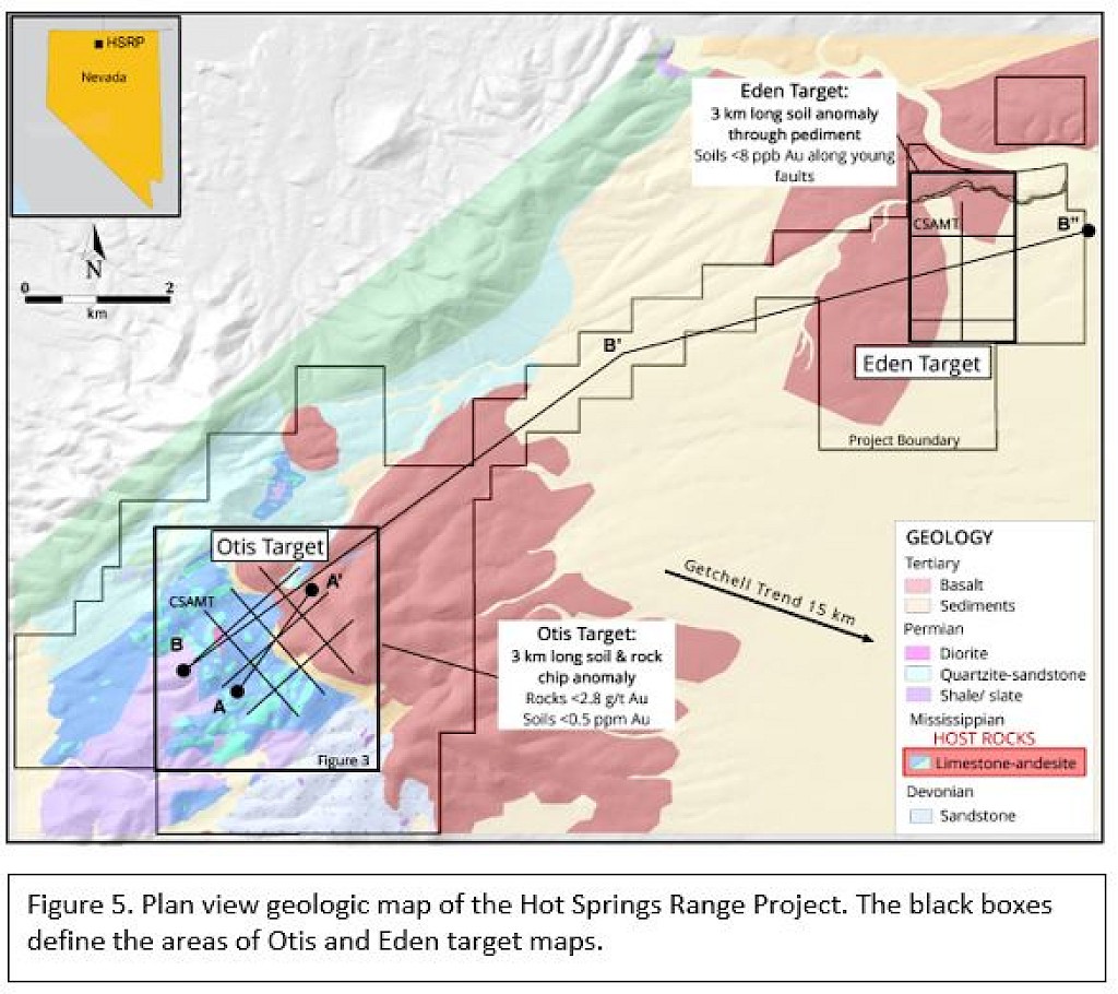
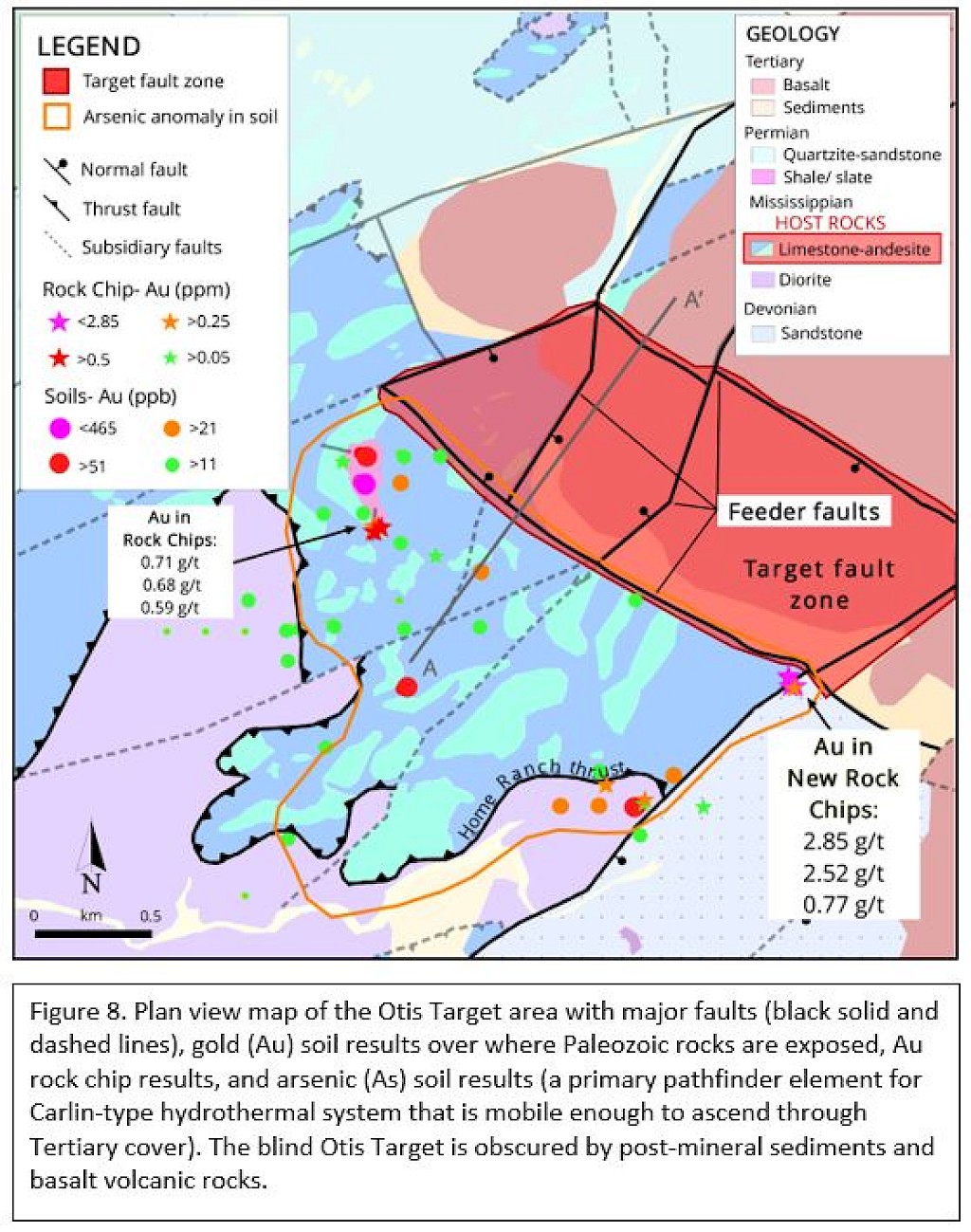
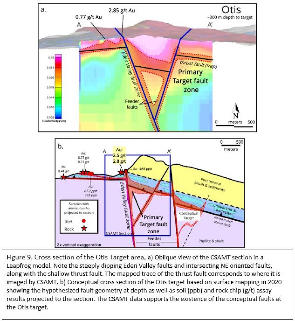
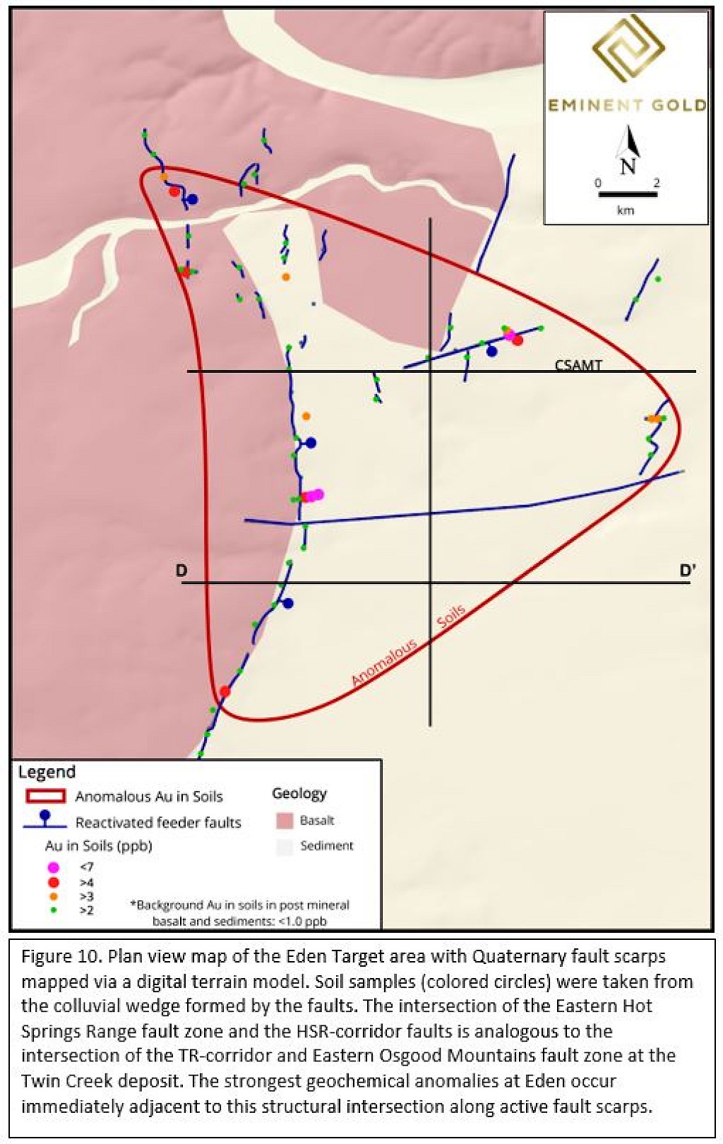
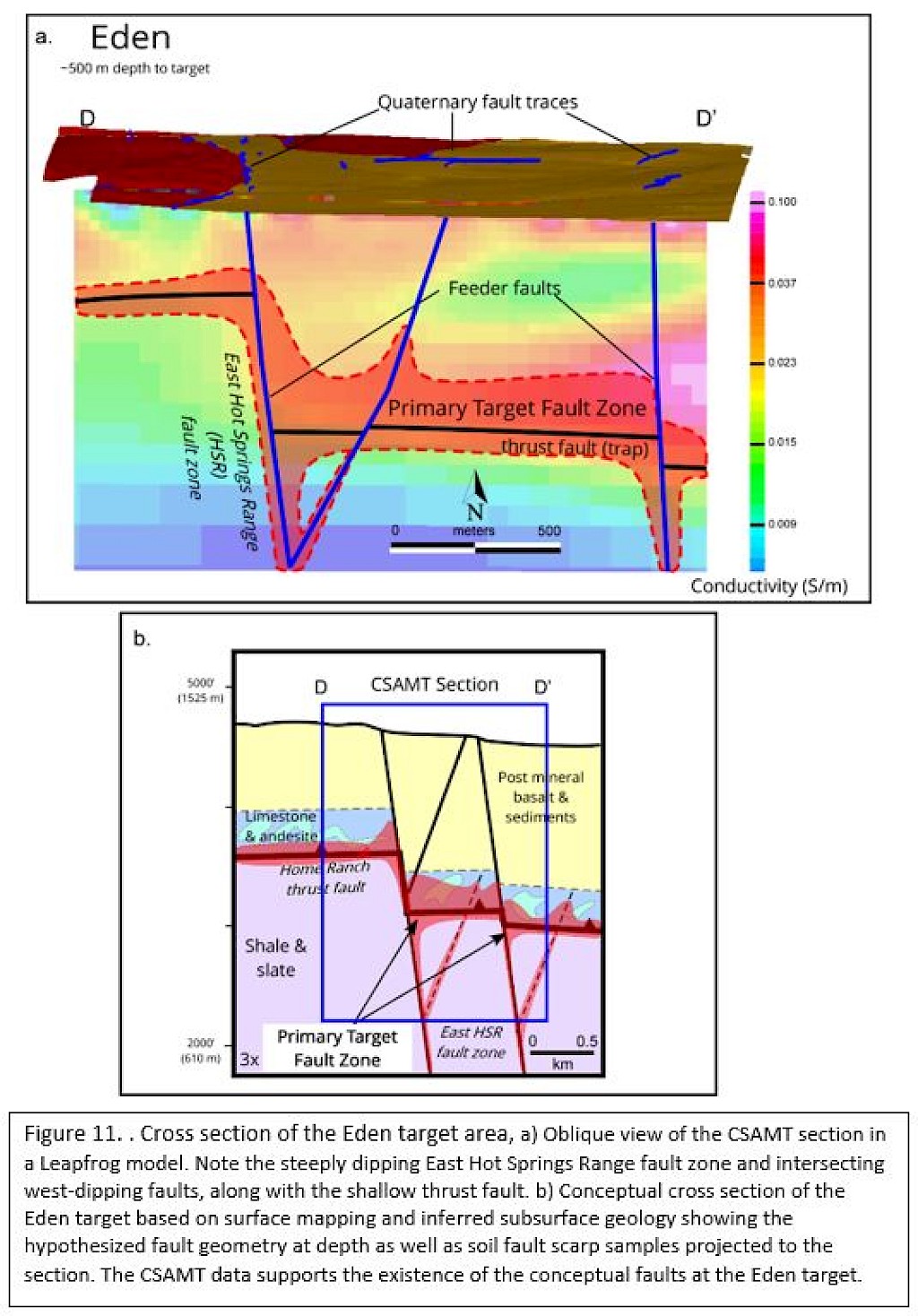
Dufresne, M., 2020, Technical Report for the Hot Springs Range Project, Humboldt County, Nevada, USA: Navy Resources.

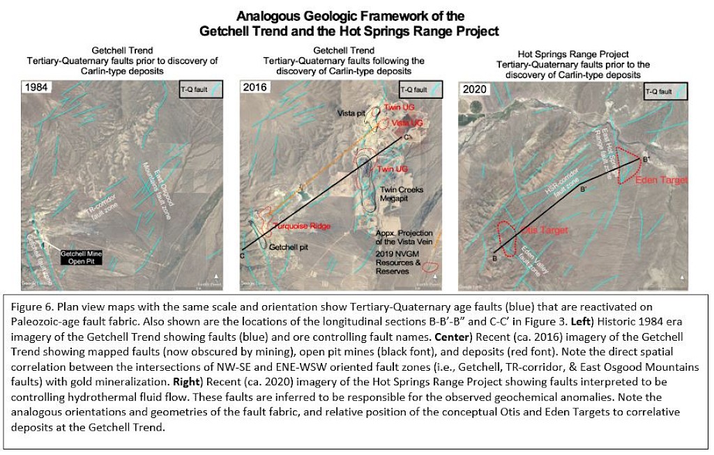
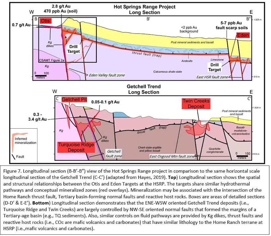
Hays, R., 2019, Geologic Synergy related to the Formation of Nevada Gold Mines, GSN Elko & Winnemucca November Meeting, Geological Society of Nevada.

Johnson, R. D., and Muntean, J. L., Hydrothermal Features in Siliclastic-Volcanic Rocks above Carbonate-Hosted High-Grade Ore at the Turquoise Ridge Carlin-Type Gold Deposit, in Proceedings Society of Economic Geologists Annual Meeting, Keystone, CO, 2018.

Master, T. D., 2017, Technical Report on the Hot Springs Peak Gold Project, Humboldt County, Nevada, USA: Buena Vista Minerals Inc.

Mihalasky, M., 1999, Mineral Potential Modelling of Gold and Silver Mineralization in the Nevada Great Basin: Ph. D. dissertation, University of Ottawa.

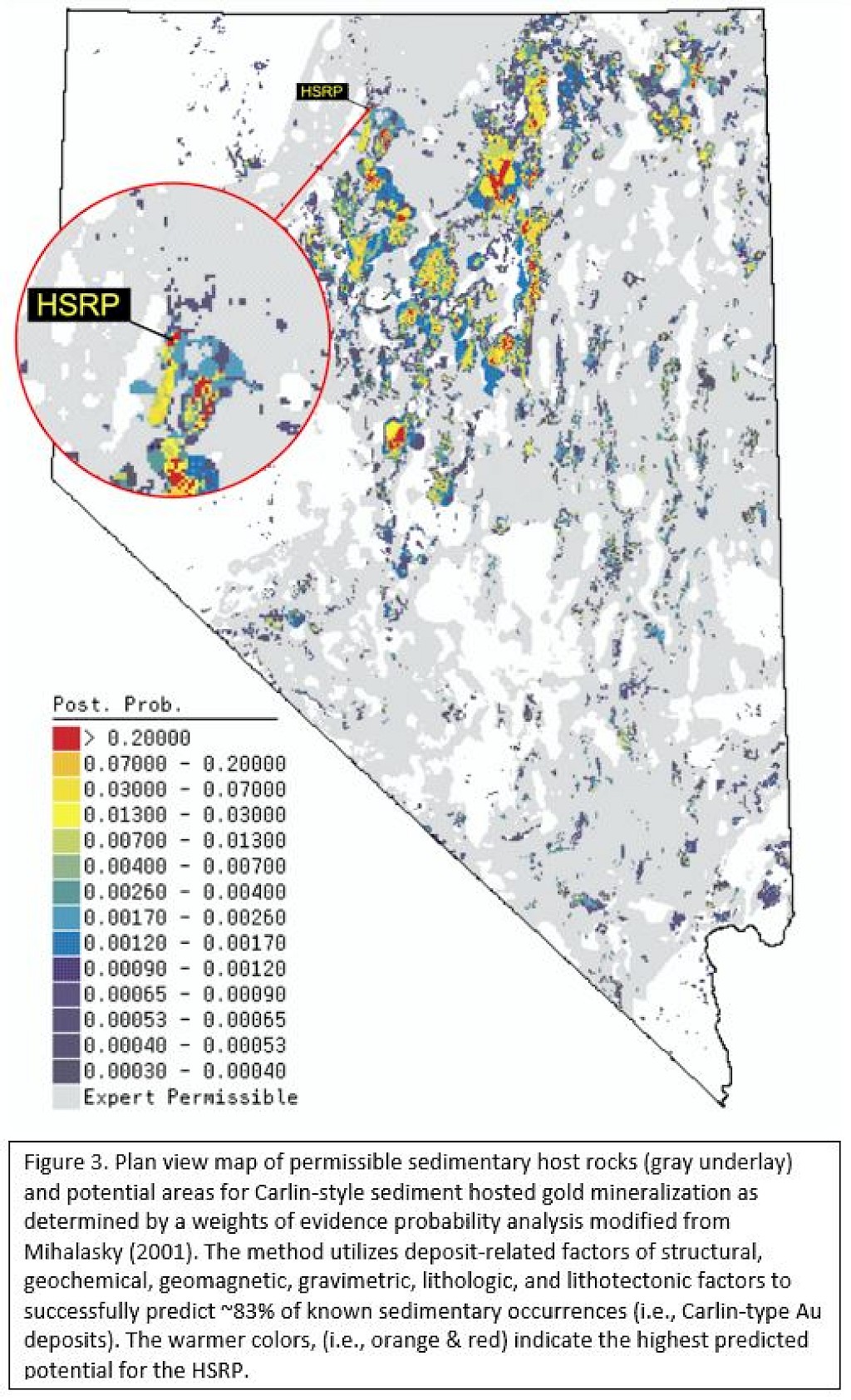
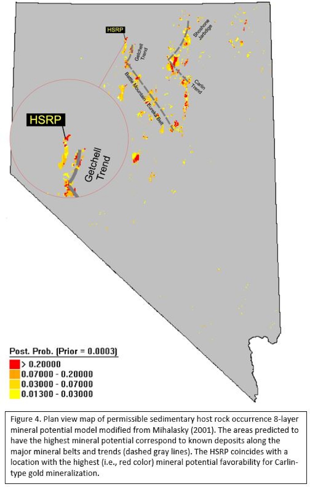
Mihalasky, M. J., 2001, Mineral Potential Modelling of Gold and Silver Mineralization in the Nevada Great Basin.

Muntean, J. L., Cassinerio, M. D., Arehart, G. B., Cline, J. S., and Longo, A. A., Fluid pathways at the Turquoise Ridge Carlin-type gold deposit, Getchell district, Nevada, in Proceedings Smart Science for Exploration and Mining, Proceedings of the Tenth Biennial Meeting of the Society of Geology Applied to Mineral Deposits, Townsville, Australia2009, p. 251-252.

Roberts, R. J., Metallogenic provinces and mineral belts in Nevada, in Proceedings AIME Pacific Southwest Mineral Industry Conference1966.